Intercomparison of Smoke Aerosol Optical Thickness Derived from GOES-8 Imager and Ground-Based Sun Photometers
Using high temporal resolution GOES-8 imager data and radiative transfer calculations, smoke aerosol optical thickness is retrieved over selected sites in South America and Central America. The degradation of the signal response in the GOES-8 visible channel is estimated and the satellite-retrieved values are in good agreement with ground-based smoke-based optical thickness for two sites in South America with mean linear correlation coefficients of 0.97. For Central America the mean correlation is 0.80. A single scattering albedo of 0.90 (at 0.67 µm) yields the best agreement between ground-based and satellite-retrieved values and is consistent with previous studies. However, our results show that the retrieved optical thickness results are sensitive to single scattering albedo and surface reflectance. Although the GOES-8 visible channel has undergone significant degradation in signal response since launch, smoke aerosol optical thickness can be estimated if proper procedures are used to account for this effect.
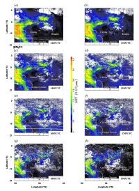
GOES-8 and NOAA-14 AVHRR Retrieval of Smoke Aerosol Optical Thickness During SCAR-B
Using the NOAA-14 1km Advanced Very High Resolution Radiometer (AVHRR) and the Geostationary Operational Environmental Satellite (GOES-8) imager data, smoke aerosol optical thickness (τ) is retrieved over land during the Smoke, Clouds and Radiation-Brazil (SCAR-B) experiment in Brazil during August-September 1995. The satellite-retrieved values are then compared against ground-based sun photometer-derived τ values from the Aerosol Robotic Network (AERONET) program. Both the AVHRR and GOES-8 retrieved τ values are in excellent agreement with the AERONET derived τ value with linear correlation coefficient of 0.93. A single scattering albedo of 0.90 (at 0.67 µm) provides the best fit between the GOES-8 and AERONET τ values. The sensitivity of the retrieved τ to assumed surface albedo and aerosol single scattering albedo are also examined. A simple multi-spectral thresholding algorithm is used to separate smoke from other features from GOES-8 satellite imagery and regional maps of τ are provided. Our resuls show that the aerosol properties used in this paper are adequate to characterize biomass burning aerosols and can be used in studies that model the role of biomass burning on regional climate.